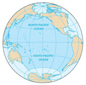
Largest of the planet's bodies of water, the Pacific Ocean covers nearly 64 million square miles, or about 28 percent of the Earth's surface, more than the combined area of the world's continents. Its width at the equator is about half the world's circumference. Size-wise, the Pacific is followed by the Atlantic, Indian, Southern, and Arctic oceans.
 Strategically important access waterways from other oceans include the La Perouse, Tsugaru, Tsushima, Taiwan, Singapore, and Torres straits. A decision by the International Hydrographic Organization in the spring of 2000 officially defined the limits of the Southern Ocean, separating it from the Pacific at the 60th parallel.
For geographical convenience, the equator divides the Pacific into the North Pacific Ocean and the South Pacific Ocean.
Exploration and settlement
The Pacific islands of the south and west were populated by Asian migrants who crossed long distances of open sea in primitive boats. European travelers, including Marco Polo (circa A.D. 1300), had reported an ocean off the Asian continent. In the late 15th century, trading ships had sailed around Africa to the western rim of the Pacific, but recognition of the Pacific as distinct from the Atlantic Ocean dates from Balboa's sighting of the Pacific's eastern shore (1513).
Magellan's crossing of the Philippines (1520–21) spurred a series of explorations by imperialistic Europe, including those of Drake, Tasman, Dampier, Cook, Bering, and Vancouver, which, by the end of the 18th century, had disclosed the coastline and the major islands. In the 16th century, imperial supremacy in the Pacific area was shared by Spain and Portugal. The English and the Dutch established footholds in the 17th century, France and Russia in the 18th, and Germany, Japan, and the United States in the 19th. Whalers and sealers sailed the Pacific from the late 18th century, and Yankee clippers entered Pacific trade routes in the early 19th century.
The oceanic economy
The Pacific is a major contributor to the world economy, particularly to those nations its waters directly touch. It provides low-cost sea transportation between East and West, extensive fishing grounds, offshore oil and gas fields, minerals, and sand and gravel for the construction industry. In 1996, more than 60 percent of the world's fish catch came from the Pacific Ocean. Exploitation of offshore oil and gas reserves is playing an increasing role in the energy supplies of the U.S., Australia, New Zealand, China, and Peru. The high cost of recovering offshore oil and gas, however, combined with the wide swings in world oil prices since 1985, has led to fluctuations in new drilling starts.
Ports and harbors
Major harbors in the Pacific include:
The Inside Passage, from southeast Alaska to Puget Sound in Washington state, offers largely storm-protected navigable waters.
Natural hazards
The Pacific basin is surrounded by a zone of violent volcanic and earthquake activity sometimes called the Ring of Fire. The ocean is subject to tropical cyclones (typhoons) in southeast and east Asia from May to December (the most frequent occur from July to October). Tropical cyclones (hurricanes) may form south of Mexico and strike Central America, the southwest U.S., and Mexico from June to October (most common in August and September). The cyclical El Niño/La Niña phenomenon occurs in the equatorial Pacific, influencing weather in the Western Hemisphere and the Eastern Pacific. Vessels are subject to superstructure icing in the extreme north from October to May. Persistent fog in the northern Pacific also can be a maritime hazard from June to December.
 The Pacific may be peaceful at times, but it is also known for its devastating storms. The fragile crust under this ocean suffers frequent earthquakes; more than 300 undersea volcanoes are still active. In 1883, the volcanic island of Krakatoa, between Java and Sumatra in the Greater Sunda Islands of the Dutch East Indies (Indonesia) blew its top, sending out 100-foot tsunamis, inundating nearby islands, killing more than 36,000 people, and raining volcanic dust over the area for more than a year afterwards.
El Niño and La Niña
El Niño is the name of a southward-flowing ocean current off the coasts of Peru and Ecuador. Cyclical changes in the pattern of its flow are the cause of environmental and climatic disturbances that cause widespread damage every few years. The current usually appears around Christmastime, so it was named El Niño, a Spanish term meaning "the child," referring to Jesus Christ. The El Niño current normally flows south from the eastward equatorial countercurrent and then converges with the northward Peru Current a few degrees south of the equator.
Atmospheric disturbances, such as those triggered by the 1982 eruption of Mexico's El Chichón volcano, cause it to occasionally extend farther south along the Peruvian coast, which is a major fishing region. El Niño's warm, but nutrient-poor waters, cause great damage to the fishing industry and also to the birds feeding in the region, which are an important source of the fertilizer, guano. The climatic effects of large-scale El Niño disturbances also can cause flooding or drought conditions over a wide area, including the western U.S. and sometimes extending as far as the southern Pacific Ocean, Europe, Africa, and Asia. Such disturbances have taken place in 1953, 1957 to 1958, 1972 to 1973, 1976, 1982 to 1983, and 1992.
In a normal year, the trade winds blow westward and push warm surface water to near Australia and New Guinea. When warm water builds up in the western Pacific Ocean, nutrient-rich cold water is drawn up off the west coast of South America and fosters the growth of the fish population.
Endangered species
Endangered marine species include the dugong (smaller cousin of the manatee), sea lion, sea otter, seals, turtles, and whales. Oil pollution in the Philippine Sea and South China Sea is a major threat to Pacific species.
European firsts
Marco Polo saw it, Balboa claimed it for Spain, Captain Cook extensively explored it, Magellan named it, Drake circumnavigated it, and Vancouver mapped it.